Tuesday, July 20, 2010

Best Motel Sign-Ever


The Cadillac Motel in Niagara Falls.

Lost Parkdale


This map shows the area of South Parkdale that was obliterated in 1956. Lost streets include:
Lorne Ave., Rose Ave., Prospect Ave., Iroquois, Mississagua and Fort Rouille as well as the lower parts of Dowling, Jameson and Dunn.
This arial photo from the late 1950's shows how much of Parkdale was destroyed to make way for the Gardiner Expressway. My Grandparents had a house on Dunn just south of the train tracks that was demolished. Compare with the photo below from 1958 as the Gardiner is being built.
Lower Parkdale in 1958.

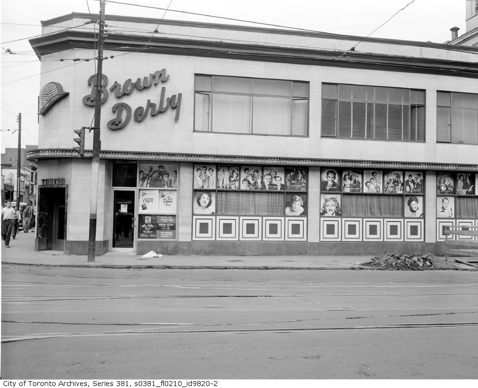
Yonge and Dundas/The Brown Derby


A vintage postcard of the long gone Brown Derby from the Chuckman Collection.
The Brown Derby, located on the N/E corner of Yonge and Dundas was open from 1949 until 1974.
The 1960's, Photo by R. Hill

Sometime in the late 1950's

In the 1970's the exterior had a "mod" face lift.
Another good shot from the 1970's. This is by Surfheart.
By the 1980's it's become a Mr. Submarine.
A Brown Derby matchbook from Chuckman's Collection.

Jamestown and Regent Park

This is what Regent Park looked like before the urban renewal of 1950.
This is after. More of a prison than a community.
This photo from the 1970's looks like a scene from the film "Up".
It's a good example of how the city planners managed to get it so wrong.
The old victorian homes of Cabbagetown that were torn down in order to build both Jamestown and Regent Park can never be brought back. If the city had simply allowed the natural progress of time to continue, these neighbourhoods would have re-gentrified
as they did in other parts of the city. The mistakes of urban renewal cannot be undone
and no doubt whatever replaces Regent Park will be as disasterous as the previous incarnation

Map of Toronto 1883

A hand drawn map of the city from 1883.
Click on the image for an enlarged view.

Monday, July 19, 2010

Richmond and Peter/Then

These houses, in what is now known as the Entertainment District, shown in 1944 are ready for demolition.
A year later they've been replaced by this building which still stands.
Up until the late 1980's there was nothing entertaining at all about this area which was all business. It was practically a ghost town on the weekends. The first "club" that I remember was  called "The Twilight Zone" located a little further east on Richmond.

Sunday, July 18, 2010

Gravenhurst Gas

An interesting Art Deco gas station in Gravenhurst, Ontario.
Perhaps it's a former B/A (British American) dealership.


The 401 and Keele/Then and Now

The 401 looking west from Keele in 1958, with 4 lanes. The recently built DHO building can be seen on the right.
The same view today with 16 lanes!
My father was a Civil Engineer with the DHO throughout the mid 50's and 60's. He writes:
"When I graduated and starting working for the Department of Highways (DHO) in the spring of 1955, I joined a small group of highway planners working in rental space in a low-rise building on Jarvis Street  (between Dundas and Carlton, I think). At that time, all parts of the Department were still growing rapidly to satisfy the pent-up demand for both road maintenance (deferred during the war years) and new roads to accommodate all the new cars.  None were produced from 1940 to 1945, and gasoline, oil, tires, etc. were rationed. Also, returning servicemen needed jobs and the Provincial Government was hiring. As a result, parts of the DHO were scattered about central Toronto which wasn't very efficient.
 
Our group's first project was to examine and evaluate all the Provincial Highways and develop a priority scheme for improvement or expansion. Without modern tools such as computers, cell phones, and digital cameras, we spent a couple of years driving and recording the physical condition, geometric configuration, volume/capacity ratio, and accident history of every mile of highway. We then prepared an evaluation report which set the stage for 20 years of highway construction. Although not a best seller outside the DHO then or now, I still have a copy of that antique document.
 
The new building in your photo was built to accommodate all the various scattered groups of employees in one spot. It seemed to be in the boondocks when we first moved in - probably in 1957 or 1958. I don't remember exactly, but I know I used to drive there in my Volkswagen Beetle from Brownfield Gardens. I can't imagine doing that today. 
 
Thanks for the stroll down memory lane."
 

Thursday, July 15, 2010

Batman 66 -What's Going on Here?


A selection of panels from Batman comics #66. Saying "boner" once or twice is funny but they just keep on repeating it....

Sheldon Hotel/Then and Now

The Sheldon Hotel on Victoria just south of Richmond in the 1940's.
Both the Sheldon and the building next door are currently vacant.

More Lost Queen Street


More shots of Queen Street that no longer exists.

Wednesday, July 14, 2010

Old House on McCaul Street

The only surviving house on McCaul Street north of Baldwin. It appears well cared for.

Bassel's Restaurant/Yonge and Gerrard


Bassel's matchbooks courtesy of the Chuckman Collection. The sort of thing most people would throw away but thankfully someone cares enough to collect this ephemera.

Like the Silver Rail at Yonge and Shuter, Bassel's was another bar on the strip that is sadly missed. Here's a collection of photos over the years. Originally Bassel's Lunch it evolved into Bassel's Restaurant and Tavern and lasted until at least 1977 (the first time I visited).

The menu.

A postcard from the early 1960's

2011.

One last shot looking south down Yonge in front of the Coronet Theatre from the late 1970's.

2010.